Today I wanted to highlight a #GoodCovidDomain that is used by a project launched by some amazing UAB researchers.
HelpBeatCovid19.org :: MAP IT. ZAP IT.
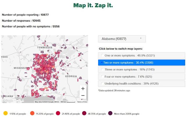
The project asks people to complete a simple survey to determine if they have COVID-19 symptoms. Then it maps their responses to help identify areas where there may be an emerging cluster of COVID-19.
Dr. Sue Feldman directs the Health Informatics program at UAB, and is a fantastic leader in her space. She’s been an R.N. for 30 years in some of the coolest and most high pressure environments in the US (I was joking with her once about how silly television shows were where doctors and nurses fly out in helicopters to accident scenes … she said “no, that’s what I used to do in Los Angeles!), and she has PhDs in both Information Technology and Education! We’ve worked together on some of her creative projects, such as teaching a cyber security tabletop exercise for future health care administrators as part of one of her classes.
Dr. Sarah Parcak is one of UAB’s most famous scientists, best known as “the Space Archaeologist” for her ground-breaking work in using satellite imagery to uncover buried remnants of ancient civilizations. After being featured on BBC specials and winning the TED Prize and publishing an award-winning science book “Archaeology from Space” I was shocked to hear her say of this Covid-19 project “Its the coolest and most important thing I’ve ever done!” She brings her expertise in all things geo-spatial and Geographic Information Systems to a new focus area with this project.
Their colleague Mohanraj Thirumalai worked for more than a decade as the Senior Web Developer at University of Illinois Chicago before getting a PhD in Management and Information Systems and moving to Alabama to be the Director of ICT at UAB/Lakeshore Research. He’s also an Assistant Professor in the School of Health Professions.
In a state like mine, Alabama, we have a great disparity in ease-of-access to medical care and as a citizen, I am concerned about whether that may be allowing Covid-19 to spread without detection in rural parts of our state.
 |
| Alabama Public Health on ArcGIS |
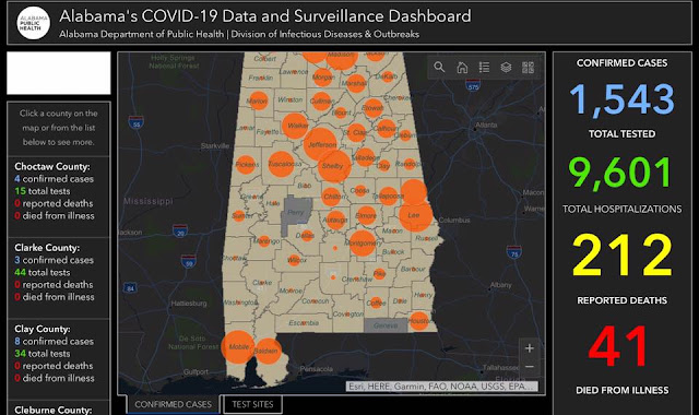
I used the Alabama Department of Public Health’s data to see what testing and infection rates looked like on a county-by-county basis in Alabama. In our ten most populous counties, we have 965 cases with 5,658 people tested (as of 10PM 3APR2020).
In our thirty smallest counties, we have 133 cases with 858 people tested. Population-wise that isn’t as bad as it sounds. The combined population of our ten largest counties is 2.6 million people, while the thirty smallest counties have 534,000 people.
But it does point to scarcity of testing. Of those thirty smallest counties, most have had less than fifty people tested IN THE WHOLE COUNTY. (Bibb = 76, very likely in the prison there! Marion = 60, and Marengo = 65.) Ten counties have had LESS THAN TWENTY PEOPLE tested in their county.
Encourage your friends to go to HELPBEATCOVID19.org and report “how they are feeling” – whether sick or healthy! ESPECIALLY if you have contacts in our more rural parts of our state.
The project actually hopes to gather data from across the SouthEast, so despite my focus on Alabama, please do encourage anyone in “the SouthEast” to share information about this project with their friends.
As more data is gathered, UAB and their partners will be able to provide a more targeted response to Covid-19 in Alabama and across the SouthEast … looking forward to seeing what emerges as we go from 10,000 participants to 100,000, to 200,000, to a million!
Advertise on IT Security News.
Read the complete article: Map It. Zap It. Covid-19 and Rural America #GoodCovidDomains
